Eye4weather
Local Weather…
Decreasing Clouds, Winds, and Seas with a possible shower/two. Sea-caution is still advised throughout the day.
Tropical Storm Erika out of local region…
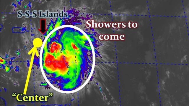
As of 5am, the center of Tropical Storm Erika is…
* Located: 17.7 N 67.7 W (+/- 270 miles WSW of St. Maarten)
* Max. winds: 50mph
* Moving: WNW at 17mph

Tropical Storm Erika has moved away from our shores, hence local weatherconditions will gradually improve today — with decreasing showers, winds, and seas…there is still a possibility for a brief shower/two.
Tropical Storm Warning issued for: Puerto Rico, Vieques, Culebra, U.S. Virgin Islands, British Virgin Islands, the Dominican Republic, Haiti, southeastern Bahamas, Central Bahamas, Turks & Caicos Islands.
A Tropical Storm Warning means tropical storm conditions are possible within the watch area, in this case, within 24 to 36 hours.
Tropical Storm Watch issued for: Northwestern Bahamas.
A Tropical Storm Watch means tropical storm conditions are possible within the watch area, in this case, within 48 hours.

(Click images to zoom in)
This will be our last update on Tropical Storm Erika.
Continue to track future storms with us this Hurricane Season.
Here are some useful links:
* Before a Hurricane
* During a Hurricane
* After a Hurricane
* Emergency Supplies Kit
According to a Press Statement from the Prime Minister of St. Maarten:
“ALL SCHOOLS and BUSINESSES (including restaurants, casinos, and ALL government services) are to RE-OPEN today, FRIDAY (28-Aug). Motorists should continue to use caution when traveling on roadways — especially in low-lying & flood-prone areas. The measures taken were of a precautionary nature in order to ensure the safety of the community and our visitors. I would like to thank the public, visitors, the business community, and the media for their understanding and cooperation.”
Stay tuned to our Facebook fan page for continual Hurricane Information.
Note:
- SSS-Islands: St. Maarten = 18.0°N, 63.1°W | Saba = 17.6°N, 63.2°W | St. Eustatius = 17.5°N, 63.0°W
- Neighboring Islands: Anguilla = 18.2°N, 63.1°W | St. Barths = 17.9°N, 62.8°W | Antigua = 17.1°N, 61.9°W | Barbuda = 17.6°N, 61.8°W | Montserrat = 16.8°N, 62.2°W | St. Kitts = 17.2°N, 62.6°W | St. Croix = 17.7°N, 64.7°W | St. Thomas = 18.3°N, 64.9°W | Tortola = 18.4°N, 64.6°W
- Remaining names for this year’
s Atlantic Hurricane Season are: Fred, Grace, Henri, Ida, Joaquin, Kate, Larry, Mindy, Nicholas, Odette, Peter, Rose, Sam, Teresa, Victor, Wanda. - Future Tropical updates will be sent out periodically (as needed).


