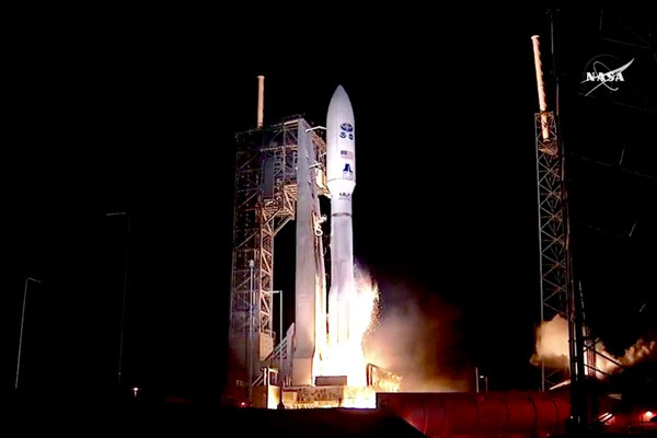
GOES-R, the first of NOAA’s highly advanced geostationary weather satellites, lifted off from Cape Canaveral, Florida, at 6:42 pm EST today. The satellite will boost the nation’s weather observation network and NOAA’s prediction capabilities, leading to more accurate and timely forecasts, watches and warnings.
In about two weeks, once GOES-R is situated in orbit 22,300 miles above Earth, it will be known as GOES-16. Within a year, after undergoing a checkout and validation of its six instruments, the new satellite will become operational.
“We are ready to receive and process GOES-R data into our forecasts as soon as it is available,” said NOAA National Weather Service Director Louis W. Uccellini, Ph.D. “Forecasters will not only have sharper, more detailed views of evolving weather systems, they will have more data – better data – ingested into our weather models to help us predict the weather tomorrow, this weekend and next week. This is a major advancement for weather forecasting.”
For the aviation sector, GOES-R will deliver clearer views of clouds at different atmospheric levels, generating better estimates of wind speed and direction and improved detection of fog, ice and lightning. This will improve aviation forecasts and flight route planning to avoid hazardous conditions such as turbulence.
“GOES-R will significantly improve the ability of emergency managers across America to prepare for, and respond to, weather-related disasters. Better situational awareness will result in better outcomes — from where to best position resources ahead of a storm to delivering more targeted information to local officials to decide if an evacuation is necessary,” said Craig Fugate, FEMA administrator.
“We’ve crossed an historic performance threshold with GOES-R,” said Stephen Volz, Ph.D., director, NOAA’s Satellite and Information Service. “NOAA is now operating the most sophisticated technology ever flown in space to help forecast weather on Earth.”
There are four satellites in the GOES-R series: –R, –S, –T and –U, which will extend NOAA’s geostationary coverage through 2036.
“NOAA and NASA have partnered for decades on successful environmental satellite missions,” said Sandra Smalley, director of NASA’s Joint Agency Satellite Division, which worked with NOAA to manage the development and launch of GOES-R. “Today’s launch continues that partnership and provides the basis for future collaboration in developing advanced weather satellites.”
Beyond weather forecasting, GOES-R will be part of SARSAT, an international satellite-based search and rescue network. The satellite is carrying a special transponder that can detect distress signals from emergency beacons.
NOAA manages the GOES-R Series Program through an integrated NOAA-NASA office. NASA’s Goddard Space Flight Center oversees the acquisition of the GOES-R series spacecraft and instruments. Lockheed Martin is responsible for the design, creation and testing of the satellites and for spacecraft processing along with developing the Geostationary Lightning Mapper and Solar Ultraviolet Imager instruments. Harris Corp. provided GOES-R’s main instrument payload, the Advanced Baseline Imager, the antenna system for data receipt and the ground segment. The Laboratory for Atmospheric and Space Physics provided the Extreme Ultraviolet and X-Ray Irradiance Sensor, and Assurance Technology Corporation provided the Space Environment In-Situ Suite.
Source NASA
For more information about GOES-R satellite visit http://www.goes-r.gov.


